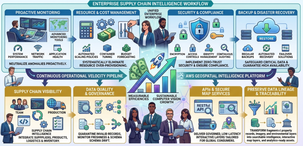
Predict Accident involves using various data sources such as historical accident data, traffic patterns, weather conditions, and road infrastructure to create a predictive model that can forecast the likelihood of accidents occurring in a given area or time frame. This model can be used by traffic authorities, law enforcement agencies, and insurance companies to improve road safety and reduce the number of accidents. The model uses machine learning techniques to analyze and learn from the data, allowing it to identify patterns and make accurate predictions. By predicting accidents, authorities can take preventative measures such as improving road infrastructure, increasing police presence, and issuing alerts to drivers to reduce the likelihood of accidents occurring. This can help save lives, reduce injuries, and minimize the economic impact of accidents on society.
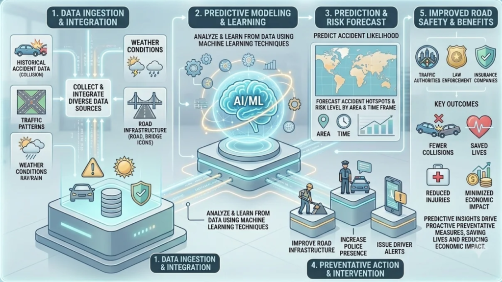
Monitor Traffic flow and intensity are important factors to monitor in urban environments. The Department of Transportation are usually interested in a variety of things such as accidents, road coverage such as snow, crime, car breakdowns, speed of cars, traffic jams and number of pedestrians. Developing a deep learning model to monitor traffic from live-feed cameras involves using advanced computer vision techniques to analyze live video feeds and extract useful information about traffic patterns and conditions. The model uses deep learning algorithms to identify and classify various objects such as vehicles, pedestrians, and traffic signs, and can also analyze traffic flow, identify congestion, and detect accidents. By monitoring traffic in real-time, authorities can make informed decisions about traffic management, road infrastructure, and emergency response. This can help reduce traffic congestion, improve safety, and minimize the environmental impact of transportation. The deep learning model can be trained on large datasets of labeled images, allowing it to continuously improve its accuracy and performance over time.
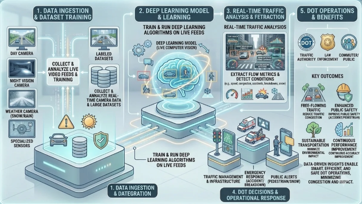
Asset Inventory Management for railway (e.g., railway, milepost, crossing, signal, switch, etc.) requires comprehensive surveying and modern asset management. Besides inventory management of existing assets, large railway companies are also interested in 1) updating the existing inventory with new assets that are placed by the US Department of Transportation and 2) dropping the old assets from inventory that are removed from the railway by the US Department of Transportation. This is a very difficult task as large railway companies have lots of long railways (~over 10K mile) across the entire US. During the last few years, most of the large railway companies started to capture LiDAR data along the railway. Most of the large railway companies currently have a large number of technicians that go through 3D point clouds to detect their desired assets manually and label them as a point feature class. We used LiDAR technology to collect 3D point cloud data of a given area and advanced deep learning algorithms to analyze the data and identify various assets such as buildings, power lines, and other structures. The deep learning model uses neural networks to identify patterns in the LiDAR data and classify objects based on their shape, size, and location. By accurately identifying assets, businesses can make informed decisions about resource allocation, risk management, and cost optimization.
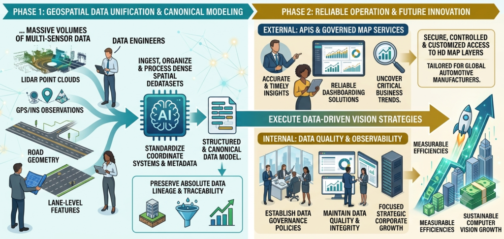
Our Autonomous Driving solutions deliver a production-grade geospatial data platform engineered to orchestrate the complete high-definition (HD) map-production lifecycle, turning massive volumes of multi-sensor data into safety-critical, customer-ready map products. The framework features automated data engineering pipelines that ingest, georeference, and process dense LiDAR point clouds, GPS/INS observations, and high-resolution imagery across distributed environments. By establishing canonical data models and standardized coordinate transformations, the platform seamlessly maps complex relationships among lane-level geometry, road features, and spatial datasets while preserving absolute data lineage and traceability. This robust architecture isolates internal production complexities through RESTful APIs and governed GeoServer map services, ensuring secure, controlled, and format-customized access tailored to the stringent requirements of global automotive manufacturers.
To accelerate release velocity without compromising safety, the platform embeds end-to-end workflow automation and high-fidelity observability engines directly into the geospatial warehouse. Automating everything from feature extraction and schema validation to customer-specific packaging compresses production timelines, delivering map releases approximately 10 times faster by eliminating manual handoffs. Concurrently, a rigorous data quality framework executes automated checks to instantly detect invalid geometry, missing features, or schema drift before delivery. This proactive, self-correcting validation system prevents degraded data from reaching production environments, transforming raw, high-velocity visual and spatial inputs into a scalable, high-availability asset for fleet operations, advanced driver-assistance systems (ADAS), and digital twins.
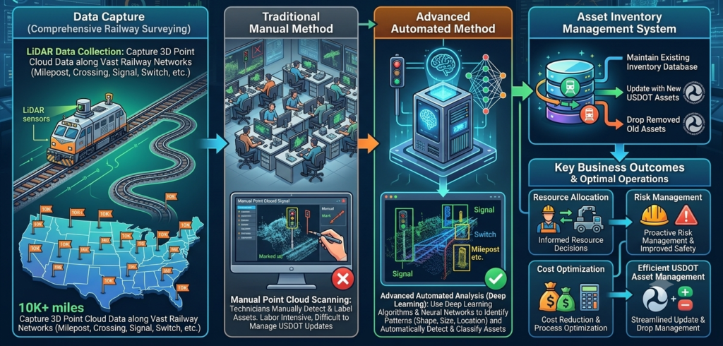
Our Enterprise Supply Chain Intelligence solution delivers a production-grade Databricks Lakehouse platform that unifies fragmented data across suppliers, procurement, logistics, and inventory into a single, governed architecture. Powered by Spark, PySpark, and Delta Lake, the platform automates batch ETL/ELT pipelines to ingest, standardize, and enrich multi-domain datasets with consistent business identifiers. By structuring data into a multi-layered framework—from raw ingestion to curated, analytics-ready consumption models—the architecture decouples source-system complexity, establishes conformed dimensions, and provides absolute multi-tier supply chain visibility. To maximize analytical velocity and ensure reliability, the platform integrates robust schema enforcement, automated validation gates, and query optimization strategies directly into pipeline orchestration. Automated checks instantly quarantine invalid records to protect trusted consumption layers from schema drift or corrupt data, while role-based access controls and end-to-end data lineage maintain strict governance. This high-performance, self-healing environment eliminates manual data preparation friction, optimizing compute utilization to drive strategic growth, accurate demand forecasting, and operational exception detection.